

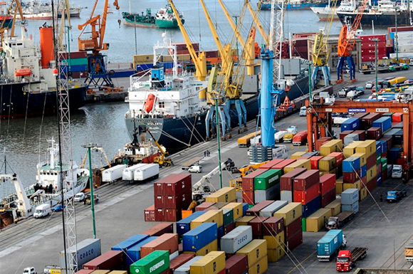
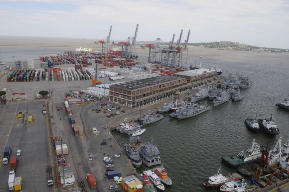
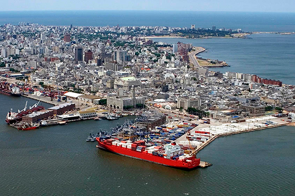
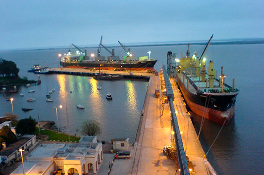
– Montevideo is the name of the capital of Uruguay as well as the name of the main port of the country.
– Montevideo port is located over the Rio de la Plata, latitude 34º55’S and longitude 56º14’O, and it is regulated by A.N.P. (National Port Administration).
– Piers are public and multipurpose and the same are assigned by said authority following a combination of vessel ETA, type of vessel as well as operations to be carried out among others. Inside Montevideo port there are 3 private terminals as follow:
- Terminal Cuenca del Plata (T.C.P.). It is a specialized container terminal operated by Katoen Natie.
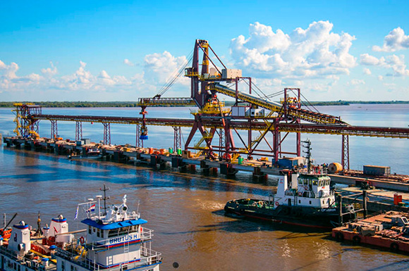
- Terminal de Graneles de Montevideo (T.G.M.). It is a specialized grain terminal.
- Tsakos dry dock.
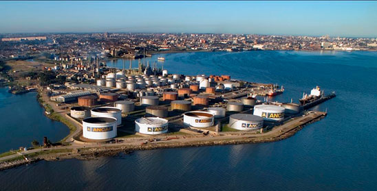
Finally at the North side of the bay, and considered also part of the port, is located the hydrocarbons terminal named La Teja which is operated by the public refinery A.N.C.A.P.
– The main channel is buoyed and dredged in all its extension (about 42 kms).
– Average tide level 0.91 meters affected basically by winds’ direction and intensity. Montevideo has 2 astronomical tides daily but mainly are regulated by the prevailing winds.
Basically winds from the South improve the tide level and from the North reduce the same.
– BW. Density as reference only between 1.009 and 1.015 (salinity is affected also by winds’ direction and intensity).
– The bottom of the main channel , the basins and all the piers is very soft mud.
– NAABSA clause recommended (customary)
– Navigation, berthing and unberthing maneuverings can be carried out during day and night.
– Use of tug and pilots is compulsory for foreign flag vessels.
– Montevideo port has facilities to comply with the following services among others: delivery of fresh water, garbage disposal, sludge disposal, grey water disposal, crew changes, delivery of provisions/spares/materials, delivery of cash to Master, etc.
– Bunkering operations can be carried either by barge or by truck
– Thanks to the law number 16.236 of 1992 better known as “ Ley de puertos “ the commercial ports of Uruguay (including Montevideo port) work under the status of free port.
Based on the same the merchandise are free of taxes while remain inside the port area having free circularization not needing any special authorization from Customs or other
authority. The existence of this regulation gives many facilities to all the cargoes that arrive in international transit including spare parts arrived either by sea freight, courier or air freight.
La Teja terminal
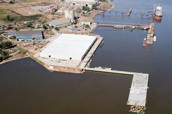
– La Teja Terminal is operated by the public refinery A.N.C.A.P.. It is located at the North side of Montevideo’s bay precisely at the end of La Teja access channel which is connected
with the main channel access to Montevideo port.
– Depending on the product to be discharged and/or to be loaded, vessels will berth either at North pier or at South pier. Terminal has also the pier West but it is not being used for commercial operations.
– Berthing is allowed at any time as there is no restrictions neither for berthing nor for unberthing maneuverings during night time, so ships will be able to proceed alongside or leave the terminal whenever needed, 24 hours a day subject to availability of shore mooring personnel, regular tide and weather conditions.
Information about North pier:
- Location: 34°52’43.98″S / 56°13’55.99″0.
- Products: to load/discharge oil products in general including lub oils.
- Vessel’s side alongside: usually port side for safety reasons (vessel must be turned at La Teja basin on arrival).
- Maximum LOA: about 180 meters subject to ANCAP final approval.
- Maximum BEAM: about 30 meters subject to ANCAP final approval.
- Connection: shore hoses connections 10 Inches.
- Rate: to be fixed between Terminal and vessel.
- Gangway: vessel’s gangway to be used.
- De-ballasting: no special requirements (ballast exchange acc to international regulations).
Information about South pier:
- Location: 34°52’49.16″S / 56°1356.70″
- Products: to discharge LPG and to load/discharge oil products.
- Vessel’s side alongside: usually starboard side for safety reasons (vessel must be turned at La Teja basin on arrival)
- Maximum LOA: about 130 meters subject to ANCAP final approval (vessels to discharge LPG).
- Remark: due to the location of the manifold at the pier.
- Maximum LOA: about 180 meters subject to ANCAP final approval (vessels to load/discharge oil products in general including lub oils).
- Maximum BEAM: about 30 meters subject to ANCAP final approval.
- Connection: shore hoses connections, 6 Inches for Gas products, 8 Inches for others.
- Rate: to be fixed between Terminal and vessel.
- Gangway: vessel’s gangway to be used.
- De-ballasting: no special requirements (ballast exchange acc to international regulations).

Nueva Palmira Port
– The Port of Nueva Palmira is located in the city of the same name, on the left bank of the Uruguay River, in the kilometer 0 of the Uruguay river strategically positioned at the beginning of the Hydrovia Parana – Paraguay.
– The navigation from Montevideo’s roads to Nueva Palmira’s roads takes as reference about 14 hrs depending on vessel loading condition, maximum drafts as well as weather conditions. The navigation upstream/downstream can carry out either with daylight or night.
– On arrival to Montevideo’s roads two river pilots appointed by the Agent will board the vessel who will assist the Captain during the whole navigation upstream.
– Navigation till “ Zona Comun “ is done through “ Punta Indio “ channel & “ Intermedio “ channel and from “ Zona Zomun “ till Nueva Palmira through “ Martin Garcia “ channel.
– Maximum draft allowed to navigate through Martin Garcia channel is 10,36 meters.
– According to the regulation covering the use and navigation of Martin Garcia channel (REMAGA) vessels, for safety reasons, must count with not less than a compulsory UKC of 60 cms to navigate through the same.
– The average river water level at Nueva Palmira port is about 0,80 meters. River water level at said place is affected directly by the tide of the River Plate due to the proximity of Nueva Palmira port with the last mentioned river. The River Plate has 2 astronomical tides daily but mainly are regulated by the prevailing winds . Basically winds from the South improve the tide level and from the North reduce the same.
– FW. Density as reference only between 0,997 and 0,9985 affected also by winds’ direction and intensity.
– Nueva Palmira’s roads is located between km 4 and km 5 of Uruguay river counting with a capacity to accommodate 3 vessels.
– The priority for berthing is based on “ first arrived first served “ taking as reference in the regular cases the arrival to either Montevideo’s roads or to Nueva Palmira’s roads. However the berthing priority is also subject to cargo readiness.
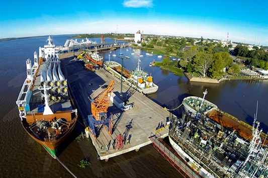
Nueva Palmira counts with 3 terminals as follow:
- Corporacion Navios. It is a specialized terminal in grains and minerals working under the law that regulate the free zone
- Ontur. It is a specialized terminal in wood pulp but can serve also other kind of merchandise like fertilizers, grains and project cargoes among others working also under the law that regulate the free zone.
- A.N.P. (National Port Administration). Said terminal counts with one public pier divided in 2. The Overseas pier South works as a multipurpose pier attending different kind of cargoes like fertilizers in bulk, liquid fertilizers, fruits, pine logs, etc. At the Overseas pier North basically are served vessels coming to load grains in bulk due to is the conveyor belt of T.G.U.
(Terminales Graneleras Uruguayas) that is directly connected to a battery of silos located inside the port facilities. Despite of above, being the Overseas pier North a public pier can be carried out other operations like transshipments to barges.
– The piers administrated by the A.N.P. are covered by law number 16.236 of 1992 better known as “ Ley de puertos “ making them work under the status of free port. The merchandise are free of taxes while remain inside the port area having free circularization not needing any special authorization from Customs or other authority.
– While vessels is operating at Nueva Palmira port can be performed other operations like crew change, provisions delivery, delivery of spare parts arrived in transit, etc.
Fray Bentos Port
– The Port of Fray Bentos is located in the city of the same name, on the left bank of the Uruguay River, 317 km away from Montevideo.
– It has 2 public and multipurpose piers for ocean vessels as follow. It has also 2 anchorage positions.
- The Transatlantic or Overseas dock, which is 200 meters length and 34 meters wide.
- The Cabotage or Linking dock, which is 225 meters length and 22 meters wide.
The facilities of the Cabotage or Linking consist in a conveyor belt directly connected with the silos that are located inside the port area.
– The main products handled in the port are fruits (citrus), pine logs and grains (barley and corn). The transatlantic dock is used for fruits (citrus) and pine logs and the cabotage or linkingdock for grains and fruits.
– On arrival to Montevideo’s roads two river pilots appointed by the Agent will board the vessel who will assist the Captain during the navigation upstream up to Fray Bentos port.
– Navigation till Zona Comun is done through Punta Indio channel & Intermedio channel and from Zona Común till Nueva Palmira through Martin Garcia channel. Navigation from Montevideo’s roads till Fray Bentos’s roads takes as reference around 18 hrs.
– Due to lack of maintenance some of the light buoys placed in the channel section from Nueva Palmira port to Fray Bentos port are turn off or out of the proper position. Considering this situation, the Uruguayan river pilots carry out the navigation through the above mentioned section of the river with daylight only for safety reasons.
– During the river navigation in the channel section from Nueva Palmira to Fray Bentos must be considered a shallow pass named “ Paso Marquez “. The depth in this section of the channel is 7,06 meters to 0 river water level. The river water level fluctuates between 0,60 meters to 1 meter depending basically on the rains that affect the upper levels of the river and its tributaries, as well as by the hydroelectric dams that there are in the river.
– As per regulation in force the compulsory safety margin under the keel (UKC) for the navigation through the channels is 0.60 meters.
– The water density as reference is 0,998 (FW).
– There is not neither air draft restriction nor beam restriction.
– The berthing as well as the unberthing maneuvering can be done during day or night.
– The berthing as well as the unberthing maneuvering must be carried with the support of 1 tug boat and pilot. In case the vessel must berth port side to quay for operational issues (normally vessels berth starboard side to quay), the support of a second tug boat could be requested by the pilots for safety reasons. This second tug could be avoiding (subject to river pilot instruction), if the vessel counts with bow thruster and the river and weather conditions is suitable to carry out a safe maneuvering with 1 tug boat only.
– There are not shore’s crane available.
– Fray Bentos port also works like Montevideo port under the status of free port. The merchandise are free of taxes while remain inside the port area having free circularization not needing any special authorization from Customs or other authority.
– While vessels is operating at Fray Bentos port can be performed other operations like crew change, provisions delivery, delivery of spare parts arrived in transit, etc.
Anchorage areas in the “ Rio de la Plata” over the Uruguayan coast
– Considering as reference from West to East there are 5 anchorage areas at the Rio de la Plata over the Uruguayan cost of said river.
– The authorization to drop anchor is granted by Coast Guard and the same is subject to draft, space, weather conditions, expected days of stay at the area, etc. Agents must grant with Coast Guard the corresponding authorization to drop anchor prior vessels arrival.
– It is not needed to use pilot to drop anchor.
– To operate at any of the anchorage area is needed to grant the inwards clearance with local authorities and later on the corresponding outwards clearance prior vessel departure.
– At the below mentioned anchorage and waiting areas can be carried out the following operations among others subject to previous Coast Guard’s authorization: bunkering, crew change, delivery of provisions/spares/materials, delivery of cargoes arrived in transit, delivery of fresh water, cash to Master delivery, reception of offloading to be sent to any destination, cargo holds cleaning, etc.. Can be carried out also cleaning of propeller, rudder and sea chest gids (full hull cleaning is not authorized) as well as under water hull inspection. Last mentioned operation normally is performed at Punta del Este’s roads due to better visibility as a result of the influence of the Atlantic ocean’s waters.
– At the below mentioned anchorage areas listed as B) and E) are performed lightering and top off operations. Both anchorage areas are under the shared jurisdiction of Uruguay and Argentina. As per the treaty of the Rio de la Plata signed between both countries, the authorities of the country involved in the commercial operation will depend either on the origin or the destination of the cargo involved.
Said anchorage areas are:
- Montevideo Anchorage and Service zone.
It is consider by Coast Guard as an extension of Montevideo port and it is under the jurisdiction of Montevideo.
It is the customary anchorage area of Montevideo port. Vessels must tender NOR there if she does not receive from Coast Guard the instruction to drop anchor at other anchorage area.
If for any reason vessel can not drop anchor at Montevideo Anchorage and Service zone, she must drop anchor at the West Anchorage and waiting area (ZEFO).
The distance from Montevideo port is about 13 NM.
- Alpha zone.
The distance from Montevideo port is about 30 NM.
It is under the jurisdiction of Montevideo.
- West Anchorage and Waiting area (ZEFO).
The distance from Montevideo port is about 39 NM.
Vessels anchored at ZEFO can be served also by service boats departing from Piriapolis port to reduce the transit time.
The distance from Piriapolis port is about 25 NM.
It is under the jurisdiction of Montevideo.
- East Anchorage and Waiting area (ZEFE).
The distance from Piriapolis port is about 18 NM.
it is under the jurisdiction of Punta del Este.
- Delta zone.
The distance from Piriapolis port is about 10 NM and from Punta del Este port about 14 NM.
it is under the jurisdiction of Punta del Este.
José Ignacio buoy
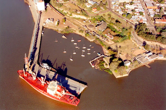
– The Owner of Jose Ignacio Terminal is A.N.C.A.P. Said company is the public refinery.
– The Terminal consists in a single point mooring buoy system, CALM configuration (Catenary Anchor Leg Mooring). It has 13 meters of diameter which allows that the moored ship rotate freely 360º according to the winds and currents condition.
– It is located at latitude 34º53’5”S and longitude 54º42’ 7”W about 2 NM from ashore.
– Water depth at the SBM as reference only is 19 meters and the average tide level is 0,84 meters.
– The maximum draught as reference only at low tide is 16,84 meters and at average tide 17 meters.
– Seabed is of clay and sand without obstacles, except for the 1.1 meter diameter sea-line.
– At the buoy area the bad weather can happen anytime with strong winds from SW, S and SE which produce high swell restricting the operations.
– In case electrical storms, strong winds or bad weather conditions the Mooring Master has the right to stop the discharging and even ask for the disconnection and unmooring of the tanker ship keeping away till the improvement of the weather/sea conditions.
– Personnel and tools are transported from Punta del Este to the tanker’s lee side by one of the Ancap’s tug boat. The Coast Guard Officers, the Pilot and the Agents embark and disembark separately by pilot boat to be coordinated by the boarding Agent.
– The ship’s derrick or crane must transfer on board all equipment for mooring and hose connection.
– The berthing maneuvering must be carried out with daylight and the limit to commence the same is up to 4 hours before sunset. The unberthing maneuvering can be carried out either during day or night.
– Use of tug and pilots is compulsory for berthing/unberting maneuverings. OSRO coverage is compulsory too. As per the regulation in force a tug boat and a support boat must be at orders next to the vessel during whole operation. Pilot must stay on board to disembark after the unberthing maneuvering is completed.
-Full operation take about 36/40 hrs based on about 1 million of barrels.
– After discharge is completed the lines have to be flushed.
– The disembarkation zone is about 2 NM South of Punta del Este.
– Subject to Mooring Master authorization can be performed crew changes, delivery of provisions/spares/materials, delivery of cargoes arrived in transit, embarkation of vetting inspector, etc.
La paloma lightering area
– Outside port limits of La Paloma are being carried ship to ship operations involving crude oil.
– The off shore STS area is called LA PALOMA LIGHTERING AREA.
– On arrival vessel can drop anchor at any place inside above mentioned area being in contact with La Paloma control center by VHF channel 16.
– Mooring Masters involved in the STS operation will provide an RVZ point for boarding party embarkation.
– It is compulsory count with OSRO coverage, a STS service provider as well as the stay at the STS operational area a support boat during the operation.
– It is not needed to appoint neither pilots nor tug boats.
– Since vessels operate beyond 24 miles of the Uruguayan territorial waters, Coast Guard does not grant any port clearance. Anyhow vessels coming to operate at La Paloma are subject to get free pratique to be granted by Health authorities prior arrival.
– Despite the above and in accordance with local regulations for La Paloma STS grounds, Uruguayan Coast Guard Officer will board the vessel together with Mooring Masters and cargo surveyors to stay on board during whole operation.
– Regarding departure procedures, the vessels will normally depart once the operation is completed and the STS equipment is retrieved by assisting work boat. EDP is normally applicable.
– While vessels are anchored at La Paloma Lightering area can be performed other operations like crew change, provisions delivery, delivery of spare parts arrived in transit, etc using the support boats positioned at La Paloma port.